You are here: start » book » physics » hillnavhint
Prerequisites
Wrap-Up: The Hill
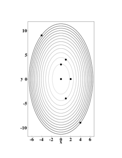
Figuring out the location of the top of the hill, and its height, should have been easy. But drawing level curves — the topo map for the hill, shown in Figure 1 — is not so easy. Don't skip this step! Feel free to use a graphics program to generate these drawings, but it is important to develop the ability to translate between equations and topo maps.
A key feature that you should have realized while answering these questions is that the gradient lives in the topo map, not on the hill. Although we think of the gradient as pointing “uphill”, the gradient of a function of two variables is a vector in the $xy$-plane. In particular, when answering the last question, your hand should have been horizontal!
In order to find the 3-dimensional vector direction of travel, you will need to combine a horizontal vector in the direction of the gradient with a vertical vector scaled so that the ratio is the steepness of the hill at the given point — which is given by the magnitude of the gradient. It is probably easiest, but not necessary, to choose the horizontal part of this vector to be a unit vector. Make sure you get the units right!
A possible extension would be to answer the same questions for the hill given by $$h=2xy-3x^2-4y^2-18x+28y+1200$$